National Weather Service says parts of Louisiana may be uninhabitable for weeks or months. Your window of time is closing. It is rapidly closing!
Hurricane Ida could be among strongest to hit Louisiana since 1850s. Category 4 storm forecast to hit Sunday afternoon.
Tens of thousands of residents in coastal communities in south-east Louisiana were under mandatory evacuation orders.
Event: Hurricane Local Statement
Alert: This product covers Southeast Louisiana and South Mississippi
IDA FORECAST TO STRENGTHEN RAPIDLY BEFORE LANDFALL
* STORM INFORMATION:
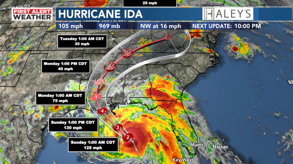
– About 240 miles southeast of New Orleans LA or about 190 miles southeast of Grand Isle LA
– 27.2N 88.0W
– Storm Intensity 105 mph
– Movement Northwest or 325 degrees at 16 mph
SITUATION OVERVIEW
Hurricane Ida in the central Gulf of Mexico continues to strengthen and is expected to intensify up to landfall. Ida is anticipated to be a major hurricane at landfall and will maintain hurricane strength well inland providing damaging to destructive winds across the area. Life threatening storm surge will impact most of the southeast Louisiana and Mississippi coast Sunday through Monday. In addition Extremely heavy rain of around 15-20 inches with locally higher amounts are expected.
Conditions are already starting to deteriorate near the coast and will continue to go downhill overnight and through the day tomorrow. All residents should have finalized their preparations. Remember, if your local officials have ordered an evacuation, leave NOW otherwise it is about time to shelter in place!
POTENTIAL IMPACTS
* SURGE:
Protect against life-threatening surge having possible catastrophic impacts across all of coastal southeast Louisiana and portions of coastal Mississippi west of Biloxi. These life-threatening impacts are expected to occur Sunday into Monday.
Potential impacts in this area include:
– Widespread deep inundation, with storm surge flooding greatly accentuated by powerful battering waves. Structural damage to buildings, with many washing away. Damage greatly compounded from considerable floating debris. Locations may be uninhabitable for an extended period.
– Near-shore escape routes and secondary roads washed out or severely flooded. Flood control systems and barriers may become stressed.
– Extreme beach erosion. New shoreline cuts possible.
– Massive damage to marinas, docks, boardwalks, and piers. Numerous small craft broken away from moorings with many lifted onshore and stranded. Also, protect against life-threatening surge having possible significant to devastating impacts across portions of coastal Mississippi east of Biloxi and along the shores of Lake Pontchartrain outside of the hurricane levee protection and Lake Maurepas. These life-threatening impacts are expected to occur Sunday into Monday.
* WIND:
Protect against life-threatening wind having possible devastating impacts across portions of Southeast Louisiana including metro New Orleans, metro Baton Rouge, Hammond, Grand Isle, and the Houma metropolitan area. These life-threatening wind impacts are expected to begin overnight along the Louisiana coast and then spread inland to the New Orleans, Houma, and Baton Rouge metro areas on Sunday.
Potential impacts in this area include:
– Structural damage to sturdy buildings, some with complete roof and wall failures. Complete destruction of mobile homes. Damage greatly accentuated by large airborne projectiles. Locations may be uninhabitable for weeks or months.
– Numerous large trees snapped or uprooted along with fences and roadway signs blown over.
– Many roads impassable from large debris, and more within urban or heavily wooded places. Many bridges, causeways, and access routes impassable.
– Widespread power and communications outages. Also, protect against life-threatening wind having possible limited to extensive impacts across portions of Southeast Louisiana to the east of the I-55 corridor. This includes the Northshore as well as all of Coastal and Southwest Mississippi. These life- threatening wind impacts are expected to occur as early as Sunday.
* FLOODING RAIN:
Protect against life-threatening rainfall flooding having possible devastating impacts across most of Southeast Louisiana including the Baton Rouge, New Orleans, and Houma metro areas and across portions of Southwest Mississippi along the I-55 corridor. These life-threatening rainfall impacts are expected to begin as early as tonight and continue through Monday.
Potential impacts include:
– Extreme rainfall flooding may prompt numerous evacuations and rescues.
– Rivers and tributaries may overwhelmingly overflow their banks in many places with deep moving water. Small streams, creeks, canals, and ditches may become raging rivers. Flood control systems and barriers may become stressed.
– Flood waters can enter numerous structures within multiple communities, some structures becoming uninhabitable or washed away. Numerous places where flood waters may cover escape routes. Streets and parking lots become rivers of raging water with underpasses submerged. Driving conditions become very dangerous. Numerous road and bridge closures with some weakened or washed out.
Protect against life-threatening rainfall flooding having possible extensive impacts across the remainder of Southeast Louisiana, Southwest Mississippi, and Coastal Mississippi. These life-threatening impacts are expected to begin as early as tonight and continue through Monday.
* TORNADOES:
Protect against a tornado event having possible limited impacts across Southeast Louisiana and South Mississippi.
Potential impacts include:
– The occurrence of isolated tornadoes can hinder the execution of emergency plans during tropical events.
– A few places may experience tornado damage, along with power and communications disruptions.
– Locations could realize roofs peeled off buildings, chimneys toppled, mobile homes pushed off foundations or overturned, large tree tops and branches snapped off, shallow-rooted trees knocked over, moving vehicles blown off roads, and small boats pulled from moorings.
PRECAUTIONARY/PREPAREDNESS ACTIONS
* EVACUATIONS:
The time is to prepare and evacuate is coming to an end quickly. Do so now or shelter in place. Do not enter evacuated areas until officials have given the all clear to return.
* OTHER PREPAREDNESS INFORMATION:
Keep cell phones well charged. Cell phone chargers for automobiles can be helpful, but be aware of your risk for deadly carbon monoxide poisoning if your car is left idling in a garage or other poorly ventilated area.
It is important to remain calm, informed, and focused during an emergency. Be patient and helpful with those you encounter.
Storm surge is the leading killer associated with tropical storms and hurricanes! Make sure you are in a safe area away from the surge zone.
Even if you are not in a surge-prone area, you could find yourself cut off by flood waters during and after the storm. Heed evacuation orders issued by the local authorities.
If a Tornado Warning is issued for your area, be ready to shelter quickly, preferably away from windows and in an interior room not prone to flooding. If driving, scan the roadside for quick shelter options.
If in a place that is vulnerable to high wind, such as near large trees, a manufactured home, upper floors of a high-rise building, or on a boat, consider moving to a safer shelter before the onset of strong winds or flooding.
Closely monitor weather.gov, NOAA Weather radio or local news outlets for official storm information. Be ready to adapt to possible changes to the forecast. Ensure you have multiple ways to receive weather warnings.
Jesus Christ is coming back, and it’s sooner than you might think!
You must be born again to enter the Kingdom of Heaven.
John 3:3-5 & John 3:16-21 & Romans 10:9-10
Get right with GOD while you still can, by accepting Jesus Christ!
Source and updates:
Hurricane Local Statement Issued by NWS New Orleans (Southeastern Louisiana)